Transport Accessibility Score
Published on
Overview
Choosing real estate based on transport accessibility is critical for business needs such as retail, logistics, and selecting a free economic zone for company registration and office placement in the Emirate of Dubai.
Transport Accessibility Score (TAS) is a composite index that evaluates the proximity of metro stations to a building’s entry point (Makani Number), distances to EV charging stations, proximity to airports, and the community-level accident risk (TAR).
Geoanalytical map of Dubai's communities
Color segmentation of Dubai's communities for common data: population. density (plp/km2), Average Crime Rate and Traffic Accident Rate are available on geoanalytical map.
Read more in description of showcase Geoanalysis of communities for risk management.
Visualization of Transport Accessibility Score on the map of Dubai
The Transport Accessibility Score and Traffic Accident Rate together reveal both strengths and constraints of locations selected for geo-analysis across Dubai communities.
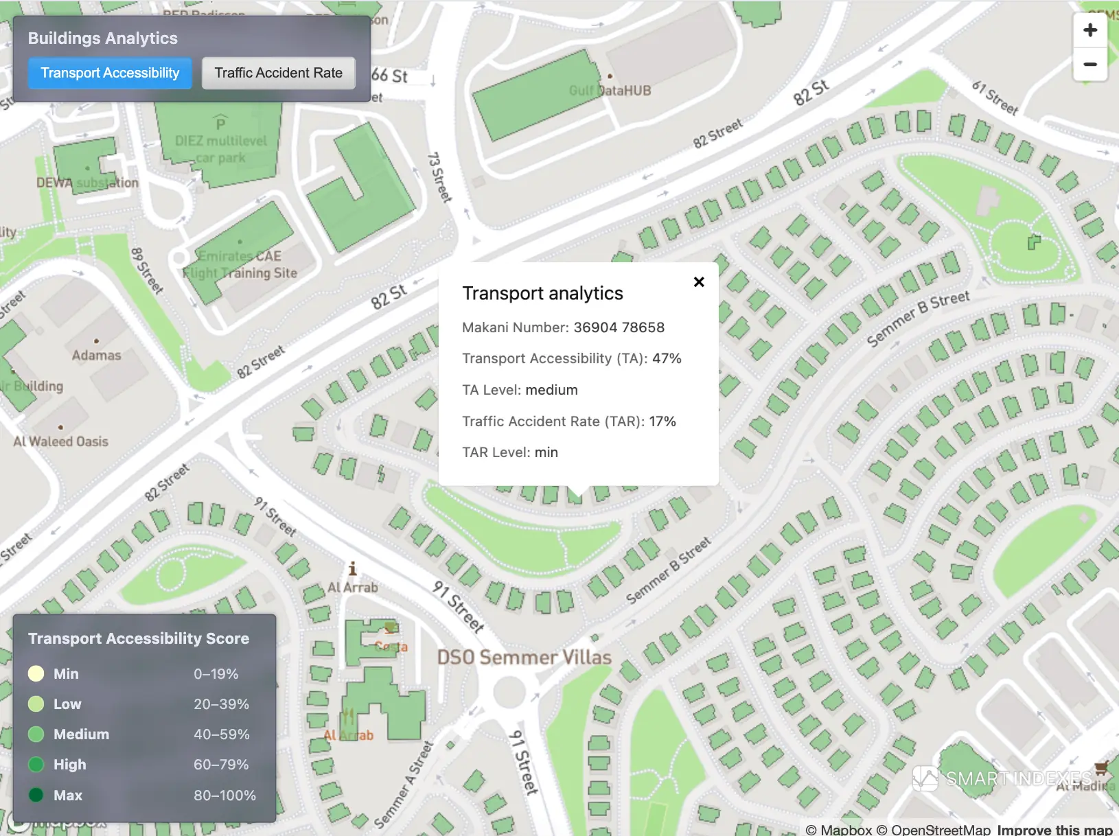 Transport Accessibility Score on Dubai’s map based on Makani Number and nearby transport hubs.
Transport Accessibility of buildings
Smart Indexes calculated TAS for Dubai buildings using:
- distance from the nearest metro station to building entry points,
- distance to EV charging stations,
- distance to the international airports DXB and DWC,
- the accident risk level in the building’s area (community TAR).
The Makani Numbers system provides the building entry point using its coordinates.
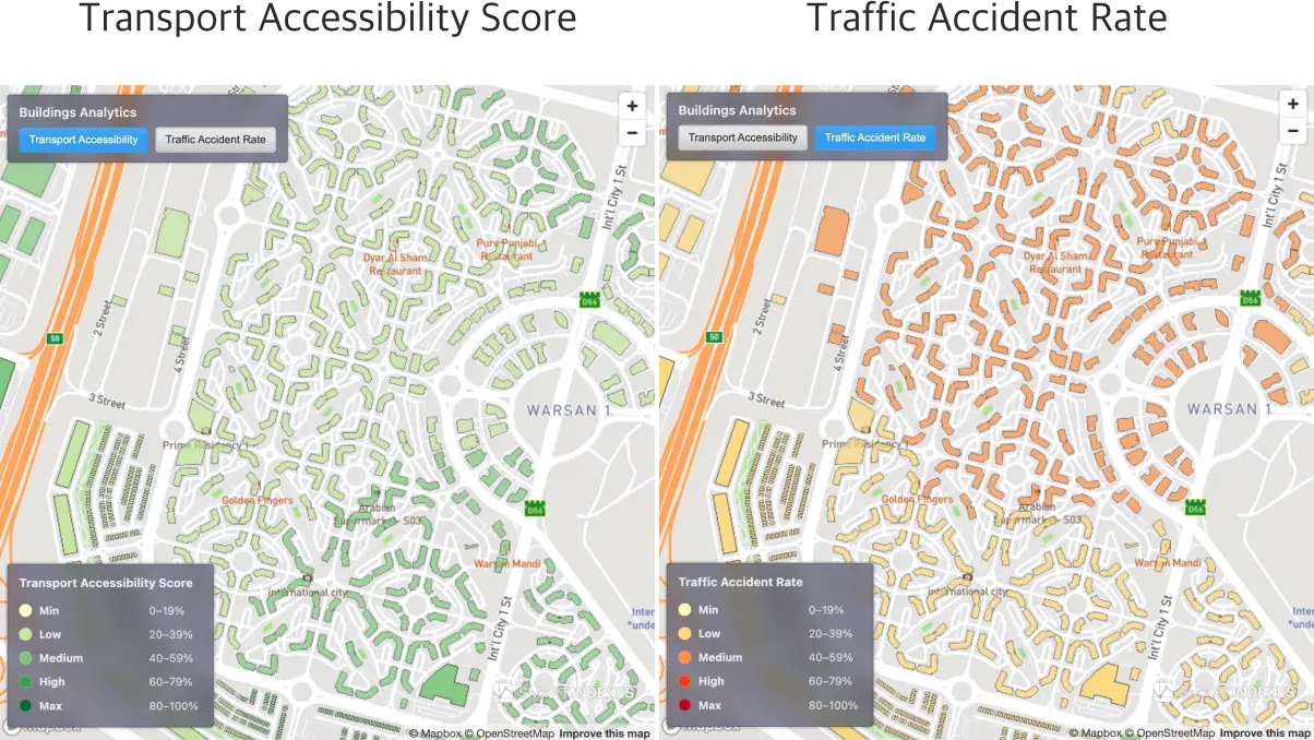 Transport Accessibility Score vs. Traffic Accident Rate on same location in community Warsan 1 of Dubai.
Aim of the analysis
The TAS calculation enables:
- Ranking Dubai buildings by transport accessibility for investment selection and location screening.
- Visual geo-analysis using color segmentation by TAS level: at city scale, community scale, and for individual buildings by Makani Number.
{
                  "type": "FeatureCollection",
                  "features": [
                    {
                      "type": "Feature",
                      "geometry": {
                        "type": "Polygon",
                        "coordinates": [
                          [
                            [55.11561402,25.114975788],
                            [55.115612719,25.114970992],
                            [55.115592098,25.11497562],
                            [55.115573106,25.114905441],
                            [55.115593727,25.114900813],
                            [55.115590841,25.114890148],
                            [55.115609191,25.11488632],
                            [55.11559414,25.114830437],
                            [55.11557685,25.114834537],
                            [55.115573108,25.114820359],
                            [55.115552546,25.114824851],
                            [55.115537004,25.114765961],
                            [55.115557566,25.114761469],
                            [55.115552425,25.114742017],
                            [55.115548948,25.11472885],
                            [55.115618381,25.114713677],
                            [55.115613056,25.114696825],
                            [55.115647306,25.114689382],
                            [55.115659307,25.114659276],
                            [55.115621009,25.114646202],
                            [55.115634484,25.114612315],
                            [55.115675915,25.114625854],
                            [55.115730049,25.114643537],
                            [55.115725437,25.114655961],
                            [55.115716909,25.11467895],
                            [55.115718766,25.114688097],
                            [55.115759385,25.114678895],
                            [55.115778221,25.114752847],
                            [55.115694766,25.114770048],
                            [55.115704458,25.114806496],
                            [55.115680463,25.114812058],
                            [55.115681982,25.114816637],
                            [55.115702395,25.114812063],
                            [55.115714748,25.114857732],
                            [55.115693402,25.114862521],
                            [55.115695463,25.11486888],
                            [55.11570889,25.11486769],
                            [55.11572607,25.114880552],
                            [55.115726782,25.114887152],
                            [55.115739757,25.114883813],
                            [55.115736459,25.114870826],
                            [55.115784,25.114860298],
                            [55.115787614,25.114874567],
                            [55.115804178,25.114871088],
                            [55.115815895,25.114917388],
                            [55.115799331,25.114920867],
                            [55.115802678,25.114934079],
                            [55.115760225,25.114943522],
                            [55.115762323,25.114951298],
                            [55.11571015,25.114962686],
                            [55.115707694,25.114955153],
                            [55.11561402,25.114975788]
                          ]
                        ]
                      },
                      "properties": {
                        "property_id": 135346837,
                        "area_id": 410,
                        "zone_id": 2,
                        "area_name_ar": "نخلة جميرا",
                        "area_name_en": "Palm Jumeirah",
                        "land_number": 1183,
                        "land_sub_number": 0,
                        "munc_zip_code": 381,
                        "munc_number": 5047,
                        "parcel_id": 3815047,
                        "bldif": 100698,
                        "pre_registration_number": "PJFRKTP02",
                        "separated_from": 995074014,
                        "separated_reference": 995074014,
                        "address": "NAKHLAT JUMEIRA - 381",
                        "community": "NAKHLAT JUMEIRA",
                        "land_type_en": "Commercial",
                        "property_sub_type_en": "Commercial",
                        "building_name": "",
                        "project_id": "",
                        "project_name_ar": "",
                        "project_name_en": "",
                        "master_project_id": 1,
                        "master_project_en": "Palm Jumeirah",
                        "master_project_ar": "نخلة جميرا",
                        "property_type_id": 1,
                        "property_type_ar": "ارض",
                        "property_type_en": "Land",
                        "property_sub_type_id": 62,
                        "property_sub_type_ar": "تجارية",
                        "actual_area": 1419.58,
                        "land_actual_area": "",
                        "building_actual_area": "",
                        "land_type_id": 4,
                        "land_type_ar": "تجارى",
                        "makani_number": "1001178986",
                        "traffic_accident_rate": 1.53,
                        "traffic_accident_rate_level": "min",
                        "traffic_accident_rate_fill_color": "#fff7bc",
                        "registered_traffic_incidents": [
                          {
                            "start_date": "2024-11-27",
                            "start_time": "21-27-41",
                            "end_date": "2025-08-07",
                            "end_time": "20-25-08",
                            "quantity": 22
                          }
                        ],
                        "transport_accessibility_score": 31,
                        "transport_accessibility_score_level": "low",
                        "transport_accessibility_score_fill_color": "#c2e699"
                      }
                    }
                  ]
                }
Relation to PTAL (London)
Transport Accessibility Score (TAS) by Smart Indexes is an analogue of the Public Transport Accessibility Level (PTAL) developed for London, adapted to the transport context of Dubai.
What TAS borrows from PTAL
- Door-level reference: accessibility is measured from the building entrance (Makani Number).
- Walk access to rapid transit is a core factor (nearest metro within realistic walking distance).
- Map-friendly segmentation into accessibility bands for visual geo-analysis.
Dubai-specific differences
- Modal set: Alongside metro proximity, TAS accounts for EV charging and access to DXB/DWC airports.
- Safety context: Incorporates community-level Traffic Accident Rate (TAR) as a negative factor.
- Anchor point: Distances are computed from the Makani entry point for precise door-to-network access.
- Output scale: Five levels (min, low, medium, high, max) for buildings, instead of PTAL’s numeric bands, better aligned with TAS map styling.
Usage of PTAL
The PTAL is used as a development planning tool in London, to determine both permitted parking standards and development densities. Large site developments (those the London boroughs refer to the Greater London Authority) must follow planning guidelines that allow more parking in areas with low PTALs (i.e., poor public transport) and vice versa, and that also relate the allowed density of development to PTAL (i.e., areas with better public transport may have higher density housing or offices).
TAS is not PTAL and is not issued by Transport for London. It is an independent index by Smart Indexes, calibrated to Dubai’s urban logistics and climate.
TAS calculation
The TAS model weights distances to key transport hubs together with community accident risk (TAR), reflecting their relative importance for accessibility analysis.
For corporate research, the model can be customized (e.g., hub lists, weights, or additional factors).