Makani Search API
Updated on
The Makani Search API consists of 35 endpoints, designed around a classified catalog of geo-objects in the Emirate of Dubai, with building entry points and geoanalytics linked through Makani Numbers (10-digit public identifiers).

Makani Search API v.2 Documentation
For all users
Full API documentation is available for users according to their needs for search and GET requests to access Dubai’s geoanalytics.
- Released on Feb. 25, 2026 — Makani Search API v.2 Documentation
- All common questions are covered in the FAQ, optimized for fast search and quick answers.
- Technical Help & Support: support@smartindexes.com
Get a Testing API Key
For new users
You can request a testing API key with a 1-week access period to explore the functionality of the Makani Search API.
- First, register your application and in the field «Description to Smart Indexes API» include a request to receive the testing API key.
- The current API pricing and License Agreement are also available upon request.
- After the 1-week testing period, you can sign the License Agreement and proceed with payment for the selected pricing plan to receive a commercial API key.
Makani Search API v.2
Full field statistics
Updated on
Makani Index of the Emirate of Dubai, UAE
| Field | Filled | Filled, % | Empty | Empty, % | Description |
|---|---|---|---|---|---|
| makani_number | 186,070 | 100% | 0 | 0% | Makani unique number |
| emirate_id | 186,070 | 100% | 0 | 0% | Increment key for Emirates of UAE |
| emirate_title | 186,070 | 100% | 0 | 0% | English title of Emirates of UAE |
| sector_id | 186,046 | 99.99% | 24 | 0.01% | Dubai urban development sector ID |
| community_number | 186,046 | 99.99% | 24 | 0.01% | Official community 3-digit key (DLD) |
| community_name_en | 186,046 | 99.99% | 24 | 0.01% | Community name (English) |
| community_name_ar | 186,069 | 100% | 1 | 0% | Community name (Arabic) |
| parcel_id | 118,850 | 63.87% | 67,220 | 36.13% | Plot number from DLD |
| property_id | 92,121 | 49.51% | 93,949 | 50.49% | Internal property key (DLD) |
| makani_address | 118,908 | 63.9% | 67,162 | 36.1% | Official address |
| building_name | 1,492 | 0.8% | 184,578 | 99.2% | Building title from DLD |
| building_number | 18,554 | 9.97% | 167,516 | 90.03% | Building number (DLD) |
| entrance_count | 186,070 | 100% | 0 | 0% | Number of entrances |
| property_sub_type_en | 18,554 | 9.97% | 167,516 | 90.03% | Property subtype (English) |
| parent_property_id | 18,554 | 9.97% | 167,516 | 90.03% | Parent building property ID |
| master_project_id | 17,482 | 9.4% | 168,588 | 90.6% | Master project ID (DLD) |
| master_project_en | 17,463 | 9.39% | 168,607 | 90.61% | Master project name (English) |
| master_project_ar | 17,459 | 9.38% | 168,611 | 90.62% | Master project name (Arabic) |
| project_id | 9,456 | 5.08% | 176,614 | 94.92% | Development project ID |
| project_name_en | 9,591 | 5.15% | 176,479 | 94.85% | Development project name (English) |
| project_name_ar | 9,456 | 5.08% | 176,614 | 94.92% | Development project name (Arabic) |
| entrance_points | 186,070 | 100% | 0 | 0% | Geo coordinates of entrances |
| geometry | 118,913 | 63.91% | 67,157 | 36.09% | Building multipolygon (OSM) |

Makani Search API v.2 — Highlights
-
In Makani Search API v.2 there are total: 35 endpoints.
- Search: 7 endpoints.
- Main geoanalytics: 13 endpoints.
- Supported geoanalytics: 15 endpoints.
- Makani Index — an official register of full, up-to-date addresses for buildings and development projects in Dubai, structured according to Dubai Land Department (DLD) identification standards.
-
Makani-based precision search
Search by Makani Number, address, parcel id, property id, project name, master project, community, or coordinates. -
Official Dubai geodata coverage
Ownership, entrances, flood risk, traffic, transport, crime, population, roads, metro, EV, retail and more. -
Property & risk analytics
Flood, traffic, crime, and accessibility indicators at multiple geographic levels. -
AI & LLM ready
Deterministic endpoints designed for AI agents, summaries, rankings, and comparisons. -
Entrance-level geometry
Exact building entrances and polygons returned in GeoJSON (WGS84). -
Secure & controlled access
API key or JWT authentication, dataset-level permissions, HTTPS-only. -
Production-grade limits
Multi-level rate limiting with full usage headers and predictable resets. -
Bulk export support
Single queries or bulk dataset access with pagination. -
Enterprise-grade focus
Designed for PropTech, analytics, AI systems, and investment workflows.
Use cases
These use cases show how Property AI Agent (or any AI agent) can interpret a query, extract a key (project name, Makani Number, coordinates, community), call the right endpoint, and return a structured, geo-analytical answer.
Below are the use cases with direct links to the documentation:
-
Property analytics by development project title
How to retrieve full geoanalytics for a specific development project.
-
Transport accessibility for a development project
Metro, public transport and road access around a building.
-
Risk management summary for a master project
Aggregated flood, crime and traffic risk indicators.
-
Top 10 safest locations by flood risk
Ranking Dubai master projects by flood exposure.
-
Building entrance by Makani Number
Locate the exact entrance point (Point + Polygon) of any registered building.
-
Comparing development projects by title
A/B/C comparison across geoanalytics and accessibility metrics.
-
Land ownership type by Makani Number
Freehold, leasehold, commonhold, usufruct, musataha — all ownership types.
-
Retail malls near a building’s entrance
Nearby retail infrastructure through spatial search.
-
EV charging stations near a building
EV charging availability within radius around a building entrance.
-
Community summary (population and density)
Population trends and density indicators for Dubai communities.
These cases are designed for teams building:
- AI property advisors
- Real estate analytic dashboards
- Location intelligence systems
- Internal broker tools
- Smart city or urban planning assistants
They demonstrate how Makani Search API v.2 can be used as a trusted geoanalytics layer across Dubai’s building-level and community-level datasets.
Purpose and usage scenarios
Makani Search API is designed to solve the following problems in the field of real estate, logistics and urban analysis:
-
Real estate search
Instant output of precise coordinates and building contours by address or development project name (english or arabic).
-
Geospatial analytics
Assessment of transport accessibility, color segmentation on map and percentage risks and price indices for choosing optimal locations.
-
Integration into PropTech segment applications
Automation of generation of geoanalytical, logistic and other maps, AI assistants and agents (based on trainable neural networks), business analytical dashboards and smart recommendations for agents and investors.
-
Logistics and delivery
Retail delivery route planning taking into account building entry points and «last mile» analysis.
-
Urban planning
Merging data layers (construction sites, infrastructure, zones risk) in a single data-driven city model.
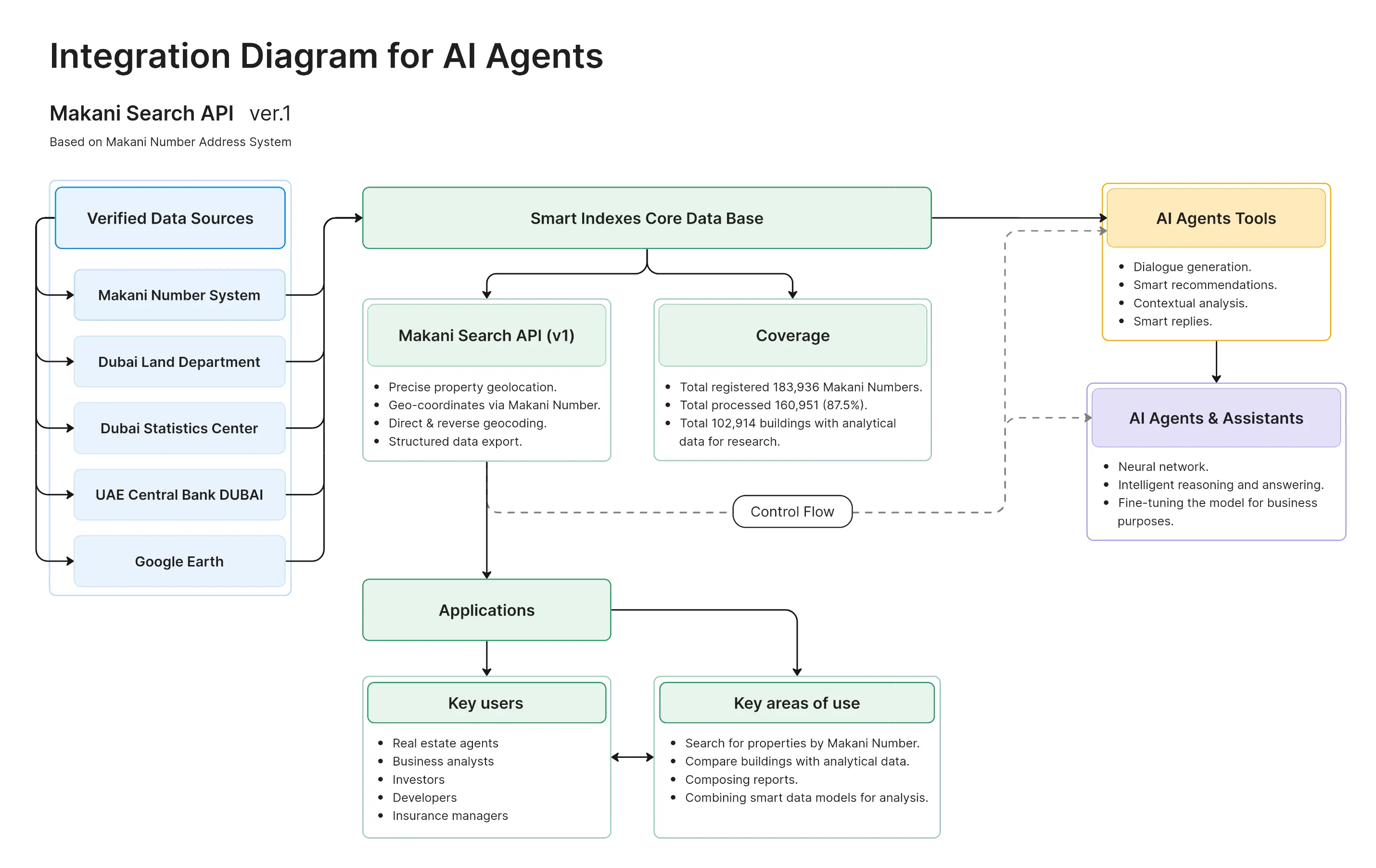
Integration with AI Agents and Data Orchestration
The Makani Search API can be integrated with AI agents to support neural network training and improve the accuracy of responses to user queries about buildings, real estate, surrounding infrastructure, and associated risks in Dubai.
The API delivers precise property geolocation via Makani Numbers, enabling AI systems to leverage structured data for dialogue generation, smart recommendations, and contextual analysis.
Combined with orchestration of spatial, statistical, and domain-specific datasets, this integration supports the development of advanced, AI-driven assistants and knowledge-based systems for the real estate sector.
Database update for Makani Search API in August 2025
As a result, data for 160,951 out of 183,936 Makani Numbers (87.5%) was generated, while for 102,914 buildings with Makani Numbers there is a full set of data, including segmentation by property ownership (those properties where sales and leases are recorded for analysis of property ownership and use).
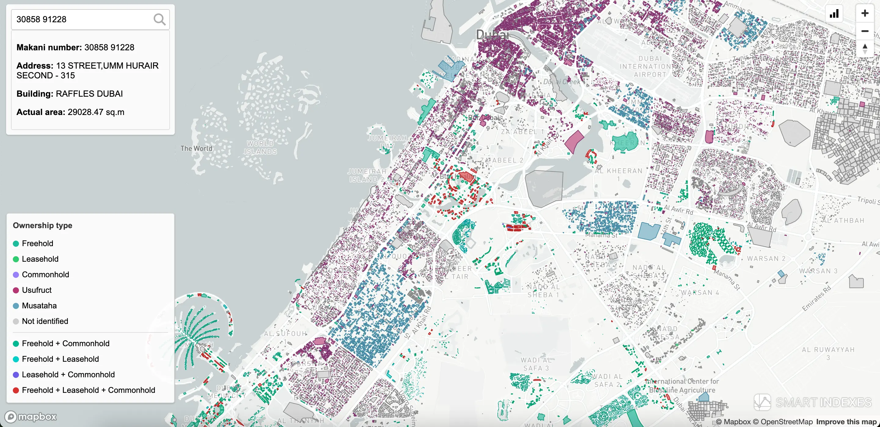 Search of building by Makani Number on Dubai's map
Dubai’s geolocation search by Makani Number System
Almost every significant plot or building in the Emirate of Dubai is assigned a unique Makani Number to standardize geolocation, logistics, and unified urban big-data solutions.
As of July 28, 2025, there are 183 936 Makani Numbers in Dubai, according to DMGISNET Entrances (Dubai Land Department).
The Makani Search API by Smart Indexes provides the geocoordinates of all Dubai buildings.
 Full map of the Emirate of Dubai, UAE, based on Makani Numbers’ coordinates
The complete map of Dubai consists of building polygons and their entry points tagged with Makani Numbers, enabling quick searches and detailed location focus.
For web developers available the Compliance Report - Makani Search API v.2 → ML Learning AI Agent
 Detailed map of the Emirate of Dubai by the Smart Indexes team
For proptech experts, this map is invaluable for analyzing master-planned developments and communities, using analytical indices and risk metrics to make balanced investment decisions.
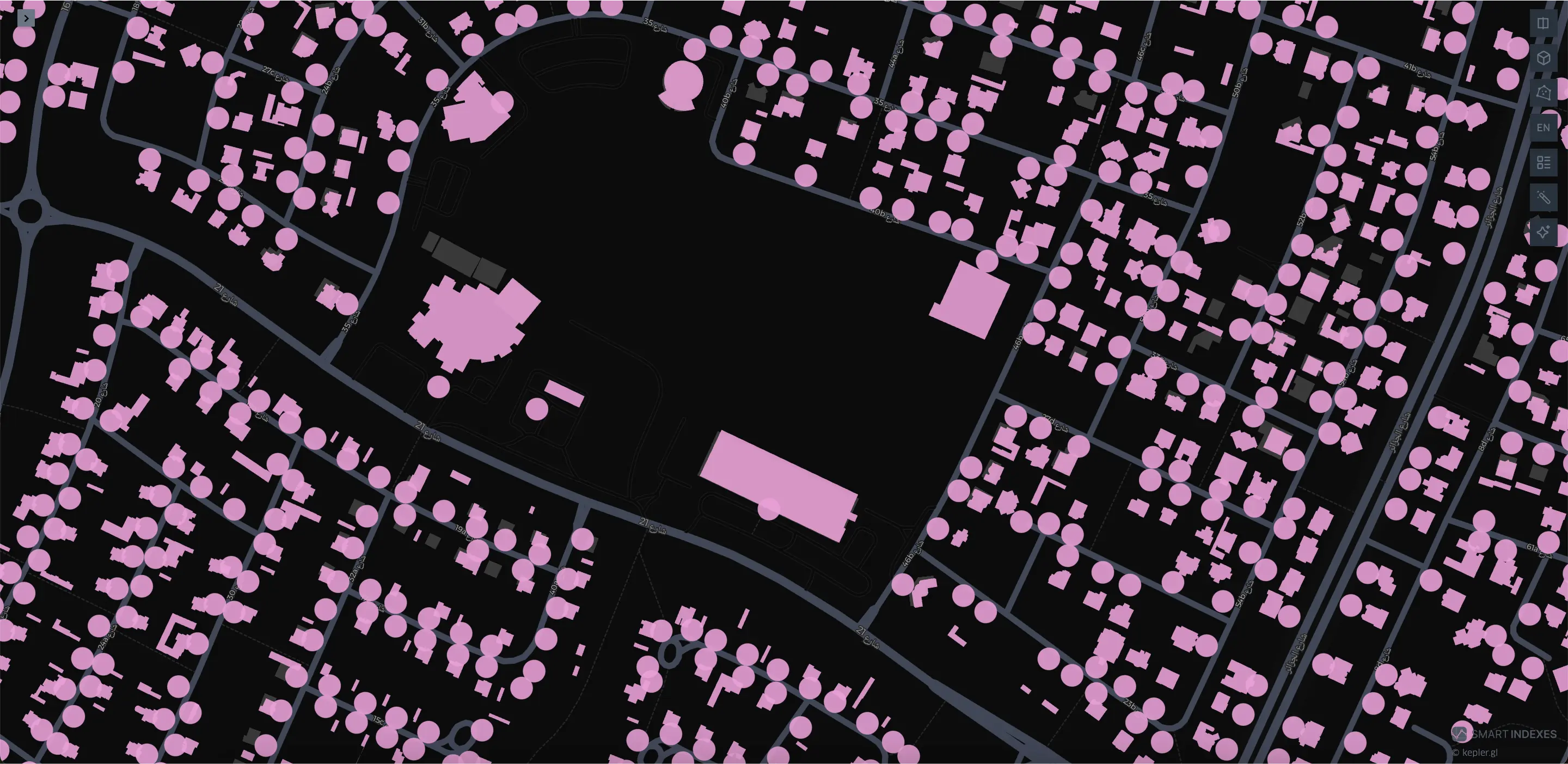 Buildings entrances on map of the Emirate of Dubai, UAE
Technical usage of Makani Index & Numbers
Makani Index is the core reference index that links together:
- Dubai Land Department (DLD) property data
- Parcel id (plot number)
- Master and development projects
- Building geometries
- Makani Numbers
Key technical value of the Makani Number addressing system is a binding unique identifier key for combining the common data for business analysis on geo, technical, transport, economic and other characteristics of the building. After Parcel ID, it is the next most important key in the Dubai Emirate GIS. Therefore, the data binding uses Makani Number as the primary binding key for the building data.
Pricing of Makani Search API
Thanks to the wide coverage of Makani Search API data, corporate users are provided with pricing on request according to selected tariffs and taking into account individual requirements.
Please visit page «Pricing of Smart Indexes APIs» to preview of economical plans.
Access to API
Available access to Makani Search API only for commercial use in applications.
The Makani Search API is an HTTP JSON API and allows you to programmatically access resources on the service, such as building summary, its entry points, transport accessibility. It accepts form-encoded request bodies (application/json), returns JSON, and uses standard HTTP verbs, response codes, and OAuth 2.0 authorization flows.
API version
Current version: v.2 (released ).
Direct and reverse geocoding
Direct geocoding allows you to obtain a Makani Number and the geometry of a building from a known address, place name, or geographic location.
Endpoint: POST /geocoding/direct/
Examples
{ "makani_number": "2687069981", "locale": "en-US" } { "type": "Feature", "properties": { "makani_number": "2687069981", "emirate_id": "2", "emirate_title": "Dubai", "sector_id": "6", "community_number": "665", "community_name_en": "WADI AL SAFA 7", "community_name_ar": "وادي الصفا 7", "parcel_id": "6653288", "property_id": "1065439036", "makani_address": "WADI AL SAFA 7 - 665", "building_name": "", "building_number": "PA4_069-265", "entrance_count": "1", "property_sub_type_en": "Villa", "parent_property_id": "1065439036", "master_project_id": "30", "master_project_en": "800 Villas", "master_project_ar": "800 فيلا", "project_id": "33434665", "project_name_en": "Serena Casa Dora", "project_name_ar": "سيرينا كاسا دورا", "entrance_points": "[[55.28397712,25.035548547],[55.28397712,25.035548547]]" }, "geometry": { "type": "Polygon", "coordinates": [ [ [55.28381084,25.035588621], [55.283810838,25.035584435], [55.283815809,25.035584432], [55.283815788,25.035555145], [55.283807171,25.035555149], [55.283807142,25.035513784], [55.283888008,25.035513736], [55.283888015,25.035524605], [55.28394038,25.035524573], [55.283940408,25.035563523], [55.283932121,25.035563528], [55.283933002,25.03558917], [55.28381084,25.035588621] ] ] }, "centroid": { "type": "Point", "coordinates": [55.283920804076,25.03557442719] }, "entrance_point": { "type": "Point", "coordinates": [55.28397712,25.035548547] } }Help & support
If you have any questions using the API, questions or want to upgrade to a paid plan, please contact us on support@smartindexes.com.
Features of Makani Search API
By connection of Makani Search API for users are available next features.
| Features | Options | Description |
|---|---|---|
| Search by Makani Number | Available for more than 100k buildings | Actual DB of Makani address index for Dubai's location. |
| Cross-Origin Resource Sharing (CORS) | AJAX requests | Makani Search API supports CORS for AJAX requests. |
| Supports main coordinate systems | OSM, MapBox, GoogleMaps, ArcGIS, MGRS | Contains coordinates for polygons and geo points for any object connected with Makani Number. |
| English & Arabic languages | Search by titles of geo objects | Supports hashmaps for quick search of geo objects using English or Arabic languages. |
| Wide building characteristics | Actual for search engines | Supports a wide range of statistical, technical, and analytical information about buildings and their locations. |
| Geopositions of buildings | Centroid of buildings | Provides geo points of building centroids and entry points based on Makani ID for logistics and delivery optimization. |
| Transport Accessibility Score | Airports, metro, bus stations | Calculates transport accessibility for 224 communities, master projects, and buildings. |
| Risk Analysis | Crime risk, flood risk, transport risk | Provides analytical risk scores for different locations based on crime rates, elevation, and transport accessibility. |
| Real Estate Analytics | Sales & rent prices, Cap Rate | Heatmaps and indexes for property prices, rental yields, and capitalization rates per building. |
| Advanced Search Filters | Developers, projects, free zones | Search by project name, developer, or free zone with detailed filtering and analytics. |
| Points of Interest | Airports, ports, fire & police stations | Includes POI data for various key infrastructure elements in Dubai. |
| Custom Reports & Data Export | PDF, Excel formats | Provides customized analytics and data exports for business intelligence and decision-making. |
FAQ
How do I connect the Makani Search API to training an AI Agent?
First, review the Makani Search API documentation in the Knowledge Base.
Next, check the pricing plans and choose the API package you need.
After that, register your application using the available web form.
The Smart Indexes team will contact you to address related technical and other questions.
Once approved, you’ll get access to the Makani Search API and can use its functionality to connect endpoints to your AI Agent for training on Smart Indexes analytical datasets, within the limits of your selected plan.
During AI Agent training, users may contact Smart Indexes Support with technical questions — our team responds in real time.
What data is available to Makani Search API users?
The Smart Indexes team has combined a broad set of geographically, technically, and economically linked datasets, enabling business analysts to conduct data-driven research and perform geo-analysis across Dubai.
- Major roads of Dubai
- Emirates of UAE
- Sectors of Dubai
- Communities of Dubai
- Lands + Buildings Ownership Segmentation
- Office buildings
- Warehouse classification
- Freezones
- Metro (2025–2030)
- Population
- Active Individuals Movement During Peak Hours (2015–2024)
- Master Projects
- Airports
- Dubai 2040
- Flood Risk
- by communities
- by master projects
- by buildings
- Transport Accident Rate (TAR):
- for communities
- for master projects
- for buildings
- Traffic Incidents
- by communities
- traffic incident statistics
- Transport Accessibility Score for buildings (Makani Number)
- Average Crime Rate (ACR)
- for communities
- Building entrances
- EV Green Chargers
How is the data in the Makani Search API verified?
All data comes from open government sources (Dubai Pulse, Dubai Statistics Center) and satellite imagery of Dubai.
The key tasks of the Smart Indexes developers are to link datasets, establish the necessary relationships, prepare hashmaps for direct and indirect addressing via search queries, and compute dynamic risk and price indices with continuous updates.
How is building transport accessibility calculated in the Makani Search API?
Transport Accessibility Score — an index of nearby transport hubs relative to a building’s entrance, calculated within a 1 km radius from the entrance coordinates (Makani Number).
It considers the proximity of metro stations and EV charging points, the distance from the airport to the building entrance, and the number of transport incidents in the area where the building is located.
First, review the Makani Search API documentation in the Knowledge Base.
Next, check the pricing plans and choose the API package you need.
After that, register your application using the available web form.
The Smart Indexes team will contact you to address related technical and other questions.
Once approved, you’ll get access to the Makani Search API and can use its functionality to connect endpoints to your AI Agent for training on Smart Indexes analytical datasets, within the limits of your selected plan.
During AI Agent training, users may contact Smart Indexes Support with technical questions — our team responds in real time.
The Smart Indexes team has combined a broad set of geographically, technically, and economically linked datasets, enabling business analysts to conduct data-driven research and perform geo-analysis across Dubai.
- Major roads of Dubai
- Emirates of UAE
- Sectors of Dubai
- Communities of Dubai
- Lands + Buildings Ownership Segmentation
- Office buildings
- Warehouse classification
- Freezones
- Metro (2025–2030)
- Population
- Active Individuals Movement During Peak Hours (2015–2024)
- Master Projects
- Airports
- Dubai 2040
- Flood Risk
- by communities
- by master projects
- by buildings
- Transport Accident Rate (TAR):
- for communities
- for master projects
- for buildings
- Traffic Incidents
- by communities
- traffic incident statistics
- Transport Accessibility Score for buildings (Makani Number)
- Average Crime Rate (ACR)
- for communities
- Building entrances
- EV Green Chargers
All data comes from open government sources (Dubai Pulse, Dubai Statistics Center) and satellite imagery of Dubai.
The key tasks of the Smart Indexes developers are to link datasets, establish the necessary relationships, prepare hashmaps for direct and indirect addressing via search queries, and compute dynamic risk and price indices with continuous updates.
Transport Accessibility Score — an index of nearby transport hubs relative to a building’s entrance, calculated within a 1 km radius from the entrance coordinates (Makani Number).
It considers the proximity of metro stations and EV charging points, the distance from the airport to the building entrance, and the number of transport incidents in the area where the building is located.
Contact us to register your app
To register your application and obtain API credentials or to book a short consultation reach us via Google Meet, WhatsApp, or email.
Also you can Register App using web form right now.
Email: support@smartindexes.com
Subject:
Please include:
- Company / contact name and role.
- Use case (research, pricing, underwriting, portfolio, etc.)
- Data scope (Communities, Master Projects, Project Names; residential/commercial; subtypes).
- Actual analytics: transport accessibility, associated risks (Flood Risk, Average Crime Rate, Traffic Accident Rate), meter rent price, meter sales price, Cap Rate.
- Estimated monthly requests.
- Preferred plan (Starter / Pro / Enterprise) and desired start date.
- Whether redistribution/embedding rights are needed.
We’ll reply with next steps, pricing, and access instructions.