Color Signal Flags for Decision-Making in Dubai’s Property Market
Intro
Dubai's dynamic real estate market is creating new expectations for all participants: a quick and objective understanding of the underlying factors behind a property's location, including its infrastructure quality, transport accessibility, risks, security, and surrounding amenities, is becoming essential.
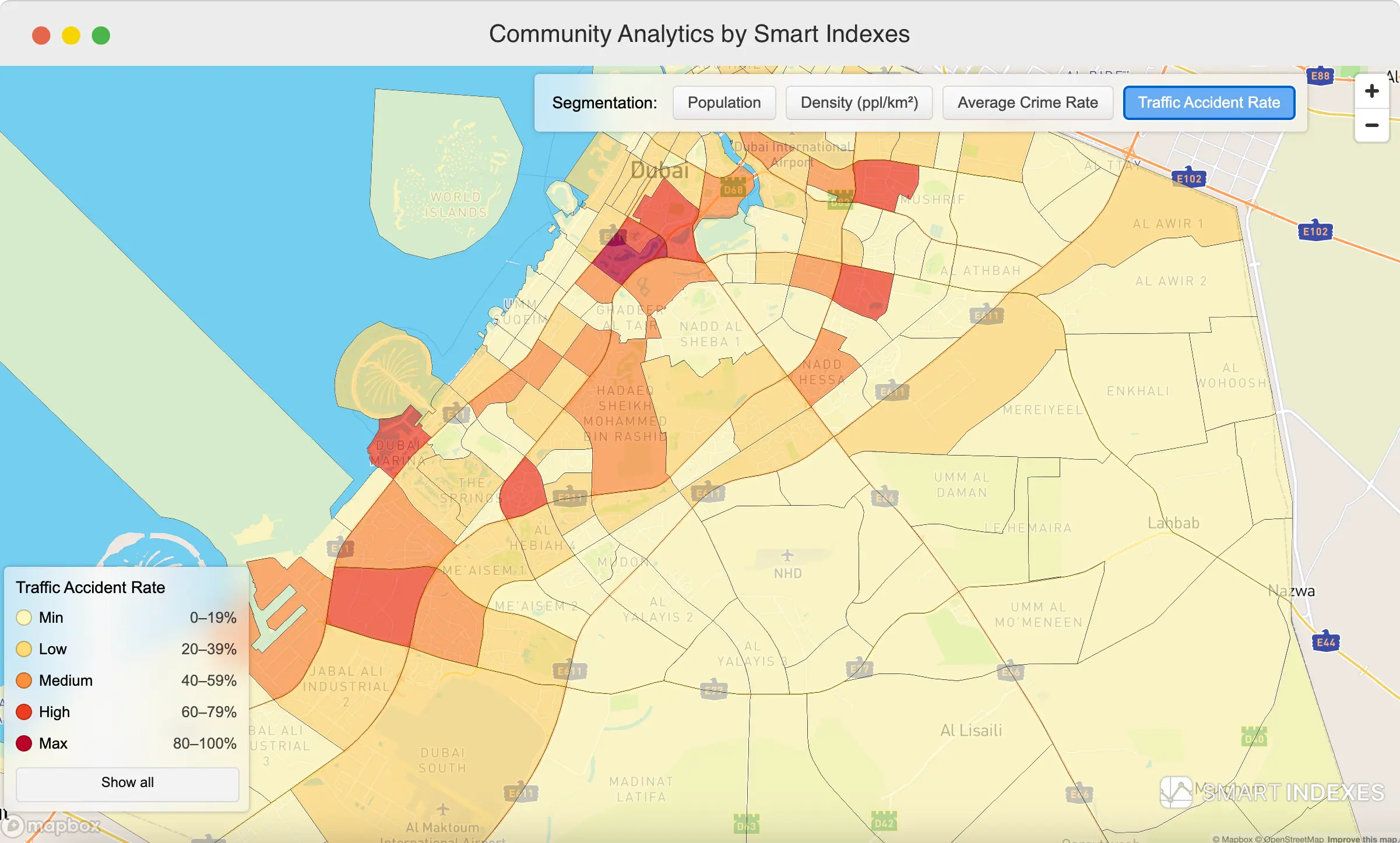 Community Analytics using Color Signal Flags (segmentation) for Decision-Making
Buyers are no longer satisfied with simply seeing an entry point on a map (Makani Number). They want to understand the social and geospatial context that influences their choice and the value of their future investment.
For proptech platforms, this directly correlates with user conversion rates. The clearer the location analytics, the higher the user trust and the likelihood of a transaction. As a result, transparency and geoanalytics are becoming core elements of product strategy.
Color Signal Flags:
A Quick Indicator of Location Quality
Color Signal Flags are color-coded indicators that simplify geoanalytics and help users instantly identify the strengths and weaknesses of a location. Color-coded risk assessment (RAG, which stands for Red, Amber, Green) is widely used in project and risk management, and in real estate it works just as effectively:
- 🟢 Green Flags → locations with low risks and strong infrastructure value
- 🟡 Yellow Flags → neutral factors requiring attention
- 🔴 Red Flags → elevated risks or potential constraints
Using the Makani Search API, these signals are generated automatically based on a Makani Number, address, or project name. With a single glance at the map, dashboard, or property card, users can immediately see where comfort, safety, and value are concentrated.
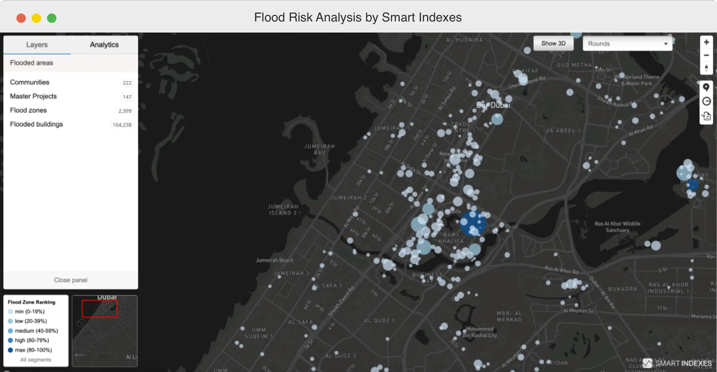 Flood Risk Analysis for Decision-Making in Dubai's Property Market
How the Makani Search API Works
The Makani Search API covers most of developed Dubai and links data to each building via its unique Makani Number.
The API provides information on key location indicators, including:
- Flood Risk
- Average Crime Rate
- Traffic Accident Rate
- Transport Accessibility Score
- geometry, entrances, roads, and transport layers
- infrastructure of master communities and developments
- nearby retail facilities, EV charging stations, airports, free zones, and other spatial elements
All these parameters are delivered in a unified structure and presented through color-coded signals. Users do not need to gather the data manually; the API organizes it into clear, actionable insights, even for those exploring Dubai’s neighborhoods for the first time.
Why This Matters for PropTech and Developers
Transparency and trust
A platform that openly presents location risks and characteristics is viewed as more reliable. Users value clear, factual information over assumptions.
Higher conversion rates
Most decisions depend on the quality of the location. When key factors are presented clearly and visually, users move more confidently from browsing to submitting an inquiry.
 Transport Accessibility Score by Buildings for choice of location using the road's analytics and routes logistics
Competitive advantage
Deep, structured geoanalytics is still rare among regional platforms.
The Makani Search API allows you to stand out through the precision and clarity of your data.
A tool for investors
Investment strategies hinge on risk-return analysis.
The Makani Search API enables risk-based ranking and helps identify optimal assets by:
- crime risk at the community level
- transport accessibility
- flood exposure
- accident rates
- master community development quality
These insights support more informed and defensible investment decisions.
Preparing for the AI ecosystem
The Makani Search API is suitable for training AI agents thanks to:
- broad coverage of geo-objects across Dubai,
- a complete geo-hierarchy from community to building,
- structured information on infrastructure, risks, and spatial context.
Platforms using such data today will be better positioned to launch accurate search assistants and recommendation systems tomorrow.
Color Signal Flags: The Clear Language of Location Analytics
Color-coded signals are intuitive for buyers, developers, and investors alike.
The Makani Search API makes geoanalytics accessible and provides structured data fit for recommendation engines and smart-ranking tools.
It gives proptech and AI developers a strong foundation to present real estate information more clearly, consistently, and accurately, enhancing both product value and user experience.
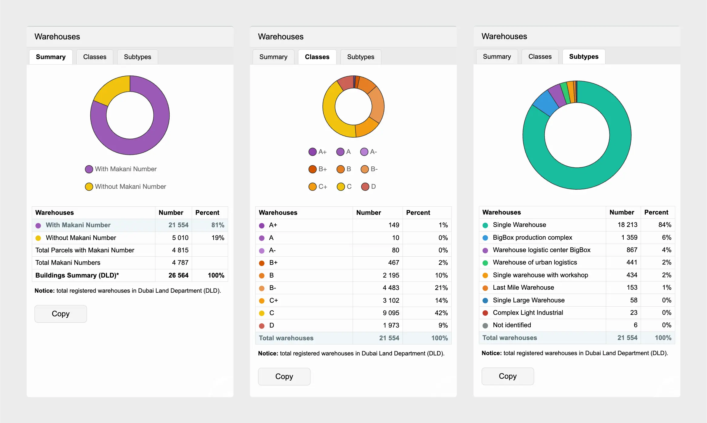 Warehouse complexes by ABCD classification in Dubai, UAE
If your platform aims to offer reliable location intelligence, improve property selection quality, and evolve toward AI-driven user assistance, Color Signal Flags and the Makani Search API can become a natural next step.
Contact us
If your team is interested in using Makani Search API and its integration for AI Agents, e-platform or GIS, please contact us: mail@smartindexes.com.
Subscribe to our Telegram channel and stay up to date with Smart Indexes updates.
Subscribe

