Risk Management in Commercial Real Estate Deals in Dubai
The Geographic Information System GIS GeoAnalytics by Smart Indexes is built for risk management. In real time it evaluates risks when selecting and benchmarking commercial properties in Dubai: meteorological, climatic and social factors, fully geo‑referenced to buildings, master development projects and communities.
Introduction
Advisory work with investors considering the acquisition of large commercial assets in the Emirate of Dubai requires close attention to accompanying risks that may lead to investment or insurance losses. Consultants must not merely mention risks but substantiate their assessment with documented, verifiable facts.
.webp)
Speed of response to investor requests matters
Complex commercial real estate transactions require a prompt response to sudden investor requests regarding possible associated risks that may pose a serious threat to the business in the near future.
The Cost of a Mistake
A wrong choice of property can result not only in direct financial losses but also in severe reputational damage for all parties: a disrupted investment strategy means missed profit and weakened influence in the region.
Why It Matters
Key characteristics of commercial real‑estate deals in Dubai:
- Fast‑growing development market
- Capital‑intensive deals
- Distinct climatic and social specifics of the region
 Fig. 1. Digitization of MODIS (NASA/Aqua) satellite images from April 18, 2024, shows flooding of 11.4 km² (33%) of the territory after record rainfall on April 16–17, 2024.
Source: MODIS (Aqua), April 18, 2024, resolution 250–1000 m, channels 7-2-1. NASA GSFC / MODIS Rapid Response Team
Key Risk Groups
Smart Indexes analysts identify two major groups of accompanying risks:
- Meteorological: flooding, extreme heat
- Social: road accidents, crime exposure
Meteorological Risks in Dubai
The methodology for calculating meteorological risks in Dubai is structured as follows:
- Historical precedents: archival satellite images before and after weather events
- Digital damage assessment: algorithms detect affected areas
- Spatial referencing: data are tied to the boundaries of 221 communities
- Ranking: a risk index is assigned to each community and master project
Geoanalytics essentials for weather risks
- Administrative structure of the Emirate of Dubai
- Hierarchy: community → master project → development project → building
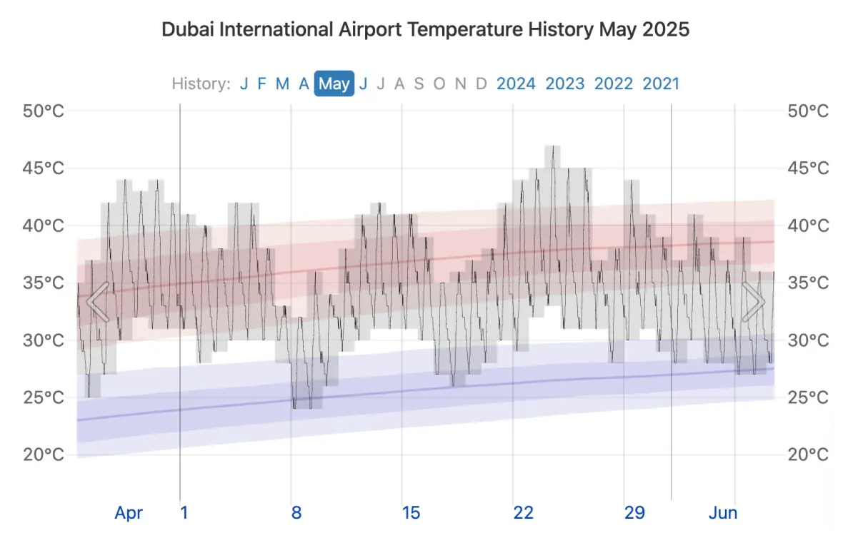 Fig. 2. Daily range of recorded temperatures (gray bars) and 24-hour maximums (red ticks) and minimums (blue ticks), plotted above daily average maximum (weak red line) and minimum (weak blue line) temperatures, with 25th–75th and 10th–90th percentile ranges.
Source: 2025 © Weather Spark
April 2024 flood case
Multispectral and radar imagery (NASA/Sentinel‑1) identified 11.4 km² of flooded land within a 35 km² polygon about 33 %. The remaining 23.6 km² (67 %) were unaffected. These figures align with Copernicus EMS and Dubai Municipality reports, validating the workflow.
Extreme‑Heat Risk
The following building metrics (from official open data) are used:
- Air‑conditioned area — floor area served by HVAC,
- Thermal load for AC — heat load, kW.
The expert edition of GeoAnalytics includes a ranking that checks whether HVAC capacity matches the building’s heat load, taking into account Dubai’s extreme‑heat factor.
Social Risks
- Road accidents: frequency of incidents within the vicinity of the property
- Crime: averaged crime exposure based on population density by community
GeoAnalytics in Practice
- Filter locations falling in flood zones
- Assess engineering readiness of buildings
- Embed risk visualisations in Due‑Diligence reports
- Gain price‑negotiation leverage when risks are above market average
Conclusion
GeoAnalytics delivers expert support to advisory teams and investors, enabling balanced, well‑reasoned decisions based on concrete risks.
Spatial risk analytics enhances transparency, reduces uncertainty and provides solid arguments at every stage of a commercial real‑estate transaction.
Subscribe to our Telegram channel and stay up to date with Smart Indexes updates.
Subscribe

