
Dubai Metro Map
This showcase is provided by Smart Indexes for informational purposes only. It showcases the capabilities of geoanalytics to address complex business challenges, including real estate investment in the Emirate of Dubai, based on Smart Indexes empirical and analytical data on geo-objects and locations in the region.
Technologies: MapBox JavaScript GeoJSON
Development of the Dubai Emirate Metro
Transport accessibility for city residents
One of the key goals of the state strategy of the Emirate of Dubai is to achieve transport accessibility of all necessary infrastructure and entertainment — within walking distance and with a choice of transport to get from point A to point B.
This prospective map of Dubai metro reflects the development plans of the Emirate for the next 5 years and the level of coverage of the metro network from 2025 to 2030. The demo version of the map shows the coverage of metro lines: the dotted lines indicate sections of lines under construction to prospective stations.

The development of the Dubai Emirate metro transport network promotes communication between communities and improves interaction between residents and visitors within the urban environment of the Dubai Emirate.
In practice, the Dubai metro map can serve as an additional geoanalytical layer when displaying real estate ads. Prices per square meter are traditionally higher within walking distance of metro stations, especially in the retail and office real estate segments.
The Dubai Metro map can serve as an additional geo-analytical layer when displaying real estate listings. Property prices per square meter are traditionally higher within walking distance of metro stations — particularly in the retail and office real estate segments.
Video
Overview
Official Dubai Metro development plans for the next five years indicate a significant expansion of the public transportation network available to residents.

Metro stations 2030 in Dubai
As of 2025, Dubai has two metro lines in operation:
- Red Line
- active: 32 stations,
- perspective: 19 stations.
- Green Line
- active: 18 stations,
- perspective: 12 stations.
 Metro Financial Centre of Dubai in 3d view
Perspective metro lines 2030 in Dubai
By 2030, the Dubai government plans to add four new metro lines and the ground railway line:
- Blue Line (Expo 2020 Branch)
- Yellow Line
- Cyan Line
- Pink Line
- Etihad Rail
 Metro Oud Metha of Dubai in 3d view
Etihad Rail
At the same time, construction of Etihad Rail — the UAE's national railway project — is underway in Dubai.
Stages of Etihad Rail construction in the UAE
Stage 1 — the freight "Gulf Corridor" from Shah to Fujairah — has been operating since 2016 but is located outside central Dubai.
Stage 2 — a mixed-use (passenger and freight) corridor connecting all seven emirates, including segments in Dubai — has been under active construction since 2022–2023 and is expected to be completed by 2026–2027.
Features of the Showcase
The video demonstrates key capabilities of our interactive map:
- Display of current and planned metro lines and stations.
- Toggle between light and dark themes for enhanced color contrast.
- Mini-map preview showing the current focus area within Dubai.
- Changing 2d into 3d view on map by switcher in one click.
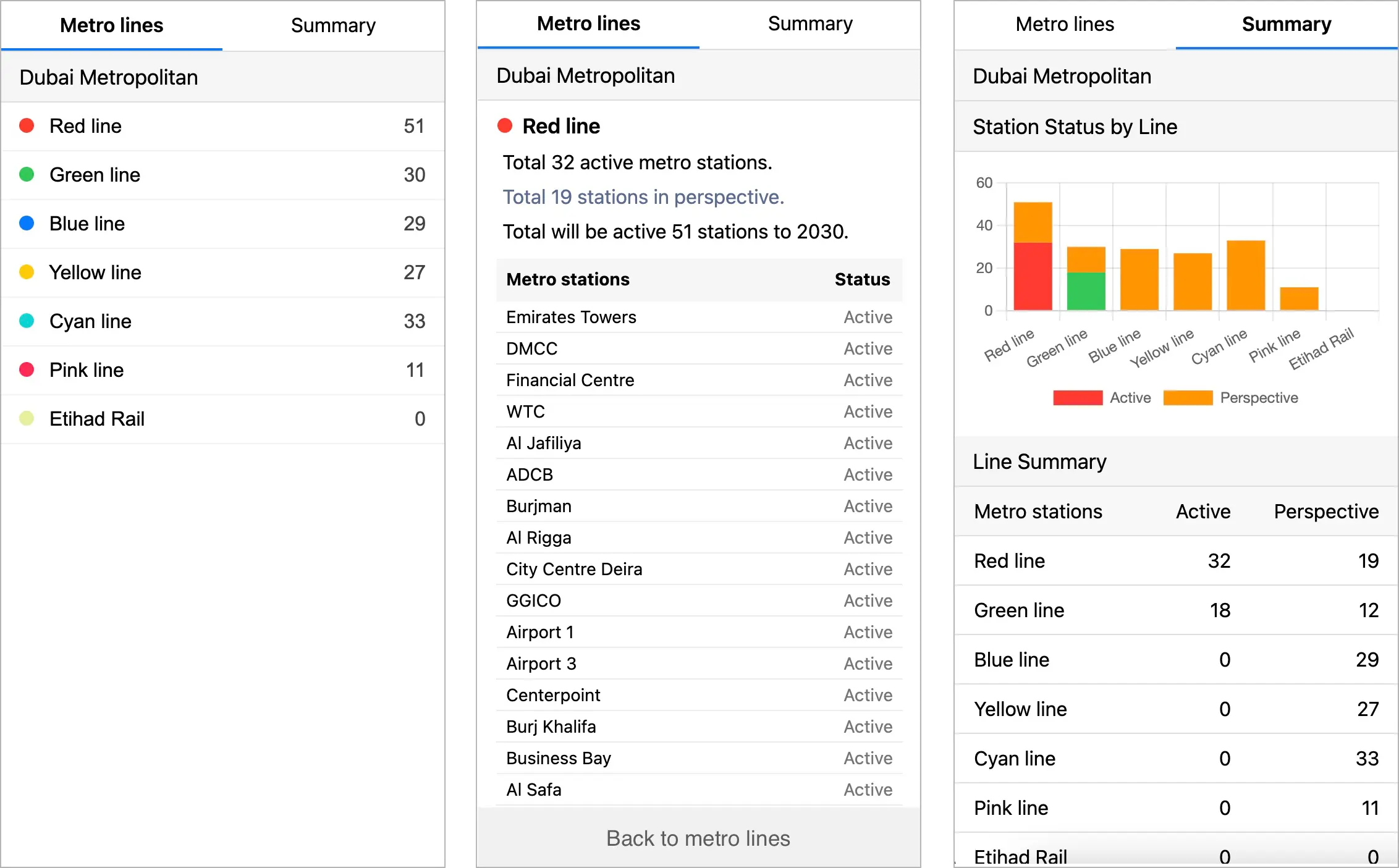 User interface: panels of geoanalytical Metro Map of Emirate of Dubai, UAE
Map User Interface
The left panel provides geo-analytical summaries, including:
- Number of current stations on each line,
- Number of prospective stations,
- Total expected number of stations by 2030,
- Miniature preview of the current focus area with a red boundary,
- Light/dark theme switcher,
- 2D/3D map view toggle.
When viewing metro lines and stations on the map, switching from light to dark theme improves visual contrast in real time.
Transport accessibility
In practice, transport accessibility of retail facilities to metro stations provides virtually stable pedestrian accessibility for residents of the Emirate, and therefore coverage for retail brands represented in shopping centers near metro stations.
Comparison of monthly metro traffic, nearby roads, as well as the capacity by the number of nearby parking spaces forms an assessment of the probable coverage for assessing the profitability of the business model for expanding the retail network for mass market retail.
Conducting geoanalysis of prospective property locations along metro routes is an effective way to support real estate investment decisions.
Dubai metro map available on request
A demo is available for corporate clients upon request. Please use the available Smart Indexes contacts.
Subscribe to our Telegram channel and stay up to date with Smart Indexes updates.
Subscribe