Lands segmentation by type of ownership in Dubai
Segmentation of land plots by type of ownership in Dubai provides a transparent benchmark for legal-form analytics and mapping of built-up parcels.
Introduction
Using Dubai Pulse Open Data and Dubai Land Department transaction records, Smart Indexes segmented all built-up land parcels across the Emirate of Dubai by their legal forms of ownership.
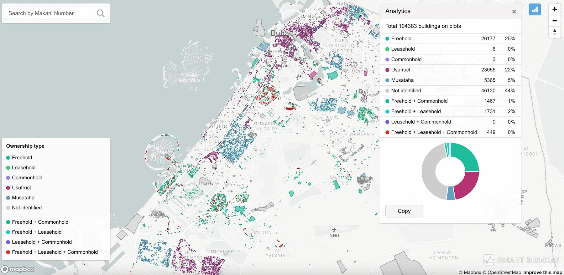 Fig.1. Lands segmentation on plots of Dubai, UAE
Note: Report "Lands segmentation by type of ownership in Dubai" based on Smart Indexes research
Background
Dubai’s Land Registry lacks complete ownership attributes for all parcels; by enriching registry records with Sales and Rent Contracts data, we infer tenure and unit-level rights across the Emirate’s built-up plots.
Open-Data Foundation
Key datasets underpinning our analysis:
- Dubai Pulse – Land Registry (dm_registration.dm_land_registry_open): parcel IDs and recorded ownership forms.
- Dubai Pulse – Building Summary (dm_building_summary_information_open): identifies parcels with constructed buildings.
- Dubai Land Department – Sales & Rent Contracts: transaction records to infer missing ownership data.
Analytical Workflow
- Filter land registry to parcels with buildings (104,383 of ~198,500).
- Parse and normalize ownership forms into canonical categories.
- Flag boolean columns for each form and their combinations.
- Aggregate counts and percentages for mapping and reporting.
Forms of Ownership
- Freehold: perpetual ownership of land and buildings; transferrable without term limits.
- Leasehold: right to use property for a fixed term (10–99 years).
- Commonhold: unit-level freehold with shared ownership of common areas.
- Usufruct: right to use and derive income (up to 99 years) without alteration rights.
- Musataha: long-term right (up to 50 years) to develop and improve land; rights revert on expiry.
- Combinations: parcels may carry multiple rights (e.g. Freehold + Commonhold).
Methodology
- Filter registry to built-up parcels.
- Extract
ownership_form_enfield and normalize to nine categories + Not identified. - Assign boolean flags for each form and combination.
- Compute segmentation metrics.
- Export CSV and GeoJSON for mapping integration.
Results
Total 104,383 built-up parcels segmented:
- Freehold: 26,177 (27%)
- Usufruct: 23,055 (22.1%)
- Musataha: 5,365 (5.1%)
- Freehold + Leasehold: 1,731 (1.7%)
- Freehold + Commonhold: 1,467 (1.4%)
- Freehold + Leasehold + Commonhold: 449 (0.4%)
- Leasehold: 6 (0%)
- Commonhold: 3 (0%)
- Not identified*: 46,130 (44.2%)
* For a significant portion of land plots, the public Dubai Land Department datasets contain no registered sale or rent transactions.
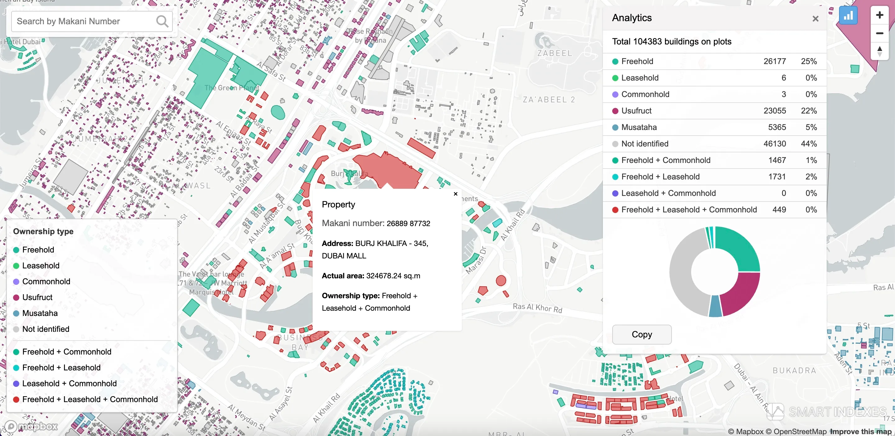 Fig.2. Segmentation of built-up land parcels by ownership type.
Key Challenges & Mitigations
- Attribute gaps → enrich with transaction data proxies.
- Non-standard naming → clean via fuzzy matching.
- Unregistered plots → flagged as Not identified for follow-up.
Deliverables
- CSV:
Land_Registry_Property_Segments.csvwith original fields + flags. - GeoJSON:
Land_Registry_Property_Segments.geojsonfor GIS platforms. - Methodology white-paper.
Conclusions
This segmentation provides a real-time overview of Dubai’s land-ownership structure, empowering data-driven investment decisions based on geospatial analytics.
Nearly half of all plots lack publicly available transaction records. This underscores the need to enrich the land registry and keep open datasets up to date, while also coordinating site selection for businesses with Dubai’s long-term development agenda set out in the Dubai Urban Master Plan 2040.
Subscribe to our Telegram channel and stay up to date with Smart Indexes updates.
Subscribe

